Information about the public boat launch area at the Giant Mine site
This information addresses topics of interest related to the remediation work that will take place at the public boat launch area at the Giant Mine site.
On this page
Anticipated schedule and phases for remediation work at the public boat launches
From now until 2028, public access is anticipated to remain minimally impacted with respect to the public boat launch and parking area, the Yellowknife Historical Society and Great Slave Sailing Club.
The Giant Mine Remediation Project’s goal is to maintain substantially uninterrupted public access to Great Slave Lake by way of the existing public boat launch, or through the area now occupied by the Great Slave Sailing Club during the open water season. However, remediation or investigation activities may cause temporary and short duration disruptions to access to the public boat launch.
The Project will work to minimize traffic disruptions to the public when scheduling work activities and will notify the public of any traffic disruptions through signage, and when appropriate, site personnel. Specific work notices will be posted at Giant Mine safety and work notices.
The Giant Mine Remediation Project understands that members of the Yellowknife boating community may have questions about how, and when, the Project’s remediation work will affect access to the public boat launch area. The information provided in this document is based on the current proposed schedule which is subject to change as remediation progresses.

Text alternative for Phase 1: present to July 2028 (may be subject to change)
This figure shows a map of the part of the Giant Mine site on which the existing public boat launch and Great Slave Sailing Club remain operational. A blue line that encompasses the sailing club, the Yellowknife Historical Society museum’s historical assets, public parking, the townsite, an existing gate and the water treatment plant outfall. A black line with dots along the old Ingraham Trail notes an existing fence. The water treatment plant outfall is shown going into the water of Yellowknife Bay. The plant outfall, the existing gate, the townsite and an area surrounding the public parking are shaded in orange to demonstrate where remediation activities are taking place during Phase 1. The legend notes these activities as the townsite deconstruction (complete), the water treatment plant outfall construction (2023 and 2024), and the deconstruction of the commissary building (2025 and 2026). The public parking, existing public boat launch, Yellowknife Historical Museum, the museum’s historical assets and the Great Slave Sailing Club are in an area shaded in green to denote public and leaseholder use. A green line to those areas shows the public use roadway. Parallel to this line and extending into the orange shaded area, an orange dashed line delineates roadways for remediation use. In Yellowknife Bay, 28 mooring locations are also marked.
Remediation activities during Phase 1 will include:
- townsite deconstruction (complete)
- water treatment plant outfall construction
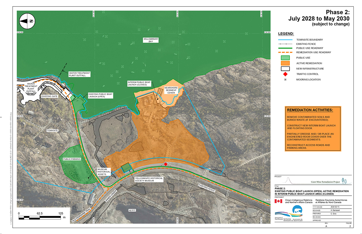
Text alternative for Phase 2: July 2028 to May 2030 (may be subject to change)
This figure shows a map of the part of the Giant Mine site on which the existing public boat launch will remain open while the interim public boat launch area is closed during remediation activities. A blue line that encompasses both these areas as well as the Yellowknife Historical Society museum’s historical assets, public parking, the townsite, an existing gate and the water treatment plant outfall. A black line with dots along the old Ingraham Trail notes an existing fence. The water treatment plant outfall is shown going into the water of Yellowknife Bay. The nearshore sediment cover, the closed interim public boat launch are down to the road and around the Yellowknife Historical Society Museum but not the museum building itself are shaded in orange to demonstrate where remediation activities are taking place during Phase 2. The legend notes these activities as removing contaminated soil and buried waste, if buried waste is encountered, constructing the new interim boat launch and floating dock, partially dredging or placing an engineered rock cover over the contaminated sediments, or both, and reconstructing access roads and parking areas. The public parking, existing public boat launch, Yellowknife Historical Museum and the museum’s historical assets are in an area shaded in green to denote public use. A green line to those areas shows the public use roadway. Parallel to this line and extending into the orange shaded area, an orange dashed line delineates roadways for remediation use. A red diamond on the road toward the museum shows where traffic control will be set up. In Yellowknife Bay, 28 mooring locations are also marked.
During Phase 2 the existing public boat launch will remain open.
In 2028, soil remediation is anticipated to begin in the areas currently occupied by the Great Slave Sailing Club and Yellowknife Historical Society, in the active construction area, as shown in orange in Figure 2. The public, including Great Slave Sailing Club members, will not have access to these areas during this time.
The Project is committed to allowing continual access to the Yellowknife Historical Society museum, however there may be times when remediation activities cause temporary and short duration disruptions to access to the museum.
Remediation activities during Phase 2 will include:
- removing contaminated soils and buried waste (if encountered)
- constructing a new interim boat launch and floating dock
- partially dredging or placing an engineered rock cover over the contaminated sediments, or both
- reconstructing access roads and parking areas
The Project will construct a new boat launch in the area currently occupied by the Great Slave Sailing Club that is comparable to the existing public boat launch to accommodate public access.
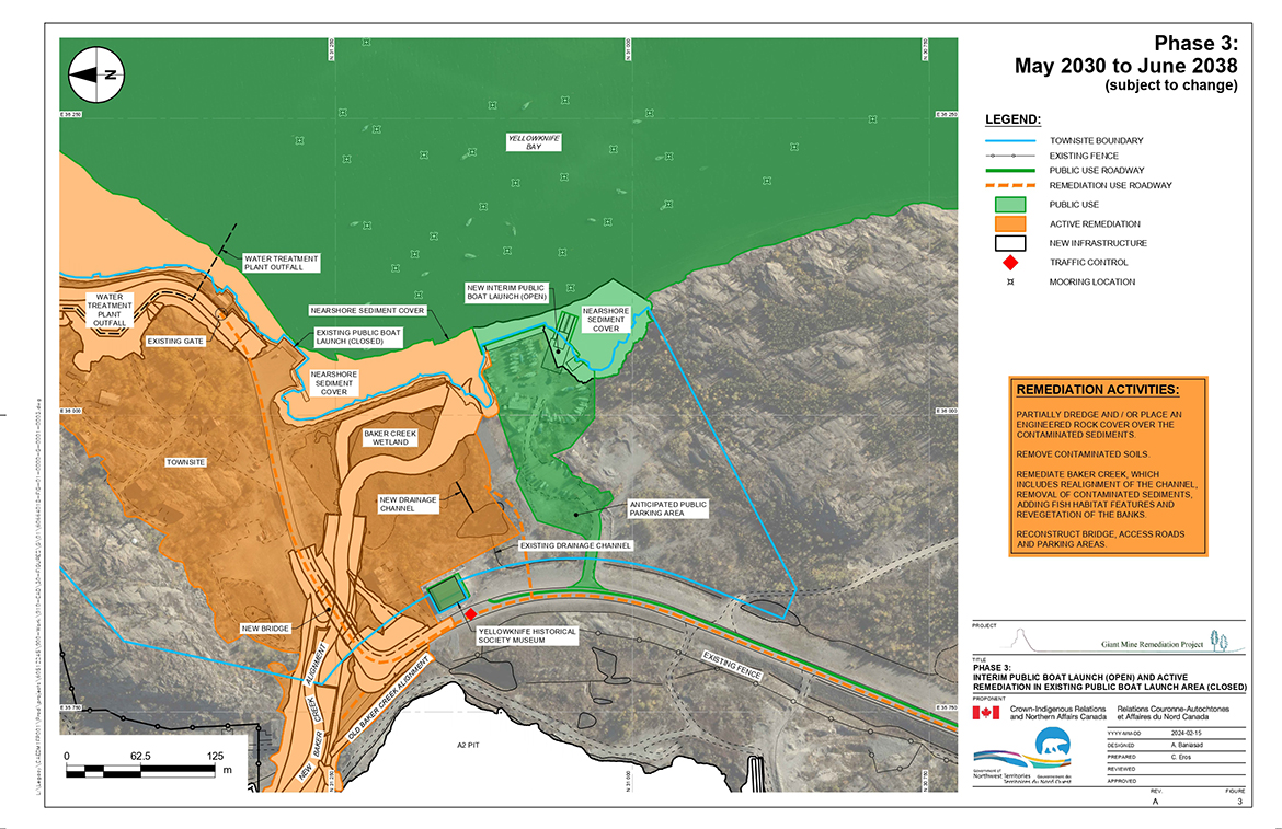
Text alternative for Phase 3: May 2030 to June 2038 (may be subject to change)
This figure shows a map of the part of the Giant Mine site on which the new interim public boat launch will remain open while the existing public boat launch area is closed during remediation activities. A blue line that encompasses both these areas as well as the Yellowknife Historical Society museum’s historical assets, public parking, the townsite, an existing gate and the water treatment plant outfall. A black line with dots along the old Ingraham Trail notes an existing fence. The water treatment plant outfall is shown going out into the water of Yellowknife Bay. The nearshore sediment cover near the boat launch, the new, open interim public boat launch area down to Yellowknife Historical Society Museum are shaded in green to demonstrate public access while remediation activities are taking place during Phase 3. In orange, more than half the map is show as undergoing remediation activities; within this area is more new sediment cover along the shore of Yellowknife Bay, the new Baker Creek alignment, a bridge over the creek, the water treatment plant outfall, the townsite, an existing gate, Baker Creek wetland and a new drainage channel. The legend denotes remediation activities as partially dredging or placing a engineered rock cover or both over contaminated sediment, removing contaminated soils, remediating Baker Creek, including realignment of the channel, removing contaminated sediments, adding fish habitat and revegetating the banks, and reconstructing access roads, bridge, and parking areas. An anticipated public parking area, the interim public boat launch, and the Yellowknife Historical Museum are in an area shaded in green to denote public use. A green line to those areas shows the public use roadway. Parallel to this line and extending into the orange shaded area, an orange dashed line delineates roadways for remediation use. A red diamond on the road toward the museum shows where traffic control will be set up. In Yellowknife Bay, 28 mooring locations are also marked.
The interim boat launch constructed during Phase 2 (in the area currently occupied by the Great Slave Sailing Club) will be open to accommodate public access to Great Slave Lake.
Public access to the existing public boat launch in the active construction area (shown in orange in Figure 3) will be restricted to project personnel to carry out remediation activities. The public, including Great Slave Sailing Club members, will not have access to the area during this time.
Remediation activities during Phase 3 will include:
- partially dredging or placing an engineered rock cover of the contaminated sediments, or both
- removing contaminated soils
- remediating Baker Creek, which includes
- realignment of the channel
- removal of contaminated sediments
- adding fish habitat features
Contact information for issues with public access areas
The Government of the Northwest Territories is responsible for areas accessible to the public throughout active remediation, and is where you can ask questions or voice concerns for any issues regarding the public boat launch. The Government of the Northwest Territories will keep the public informed of any disruptions to access to the boat launches due to remediation activities.
If you have questions or wish to make a report, you can do so by emailing publicuse_giant_lieupublic@gov.nt.ca or calling (867) 767-9236 Ext 53190
More info: Government of the Northwest Territories’ Giant Mine Townsite and Boat Launch webpage
Boat launch design details
The Project has an approved design for the new interim public boat launch available on the Mackenzie Valley Land and Water Board’s public registry. The project committed to constructing a new boat ramp in the area now occupied by the Great Slave Sailing Club that is comparable to the current public boat launch.
How the Project shares updates about remediation work at the Giant Mine site
The following are ways in which information will be shared:
- meetings and discussions with Rights holders and stakeholders
- Giant Mine Remediation Project annual Public Forum event
- attendance at trade shows and other public venues
- Giant Mine Remediation Project webpage
- Giant Mine Remediation Project safety notices and work notices webpage
For questions about the Giant Mine Remediation Project, or to be added to the email distribution list please call 867-444-9427 or email us.